Pioneer Fire forces evacuations in Priest River

A plane drops fire retardant on the Pioneer Fire, located about 3 miles northwest of Priest River. Reported in the early afternoon, the fire has burned several hundred acres and forced the evacuation of nearby residents.
(Photo courtesy ROB SOUMAS)
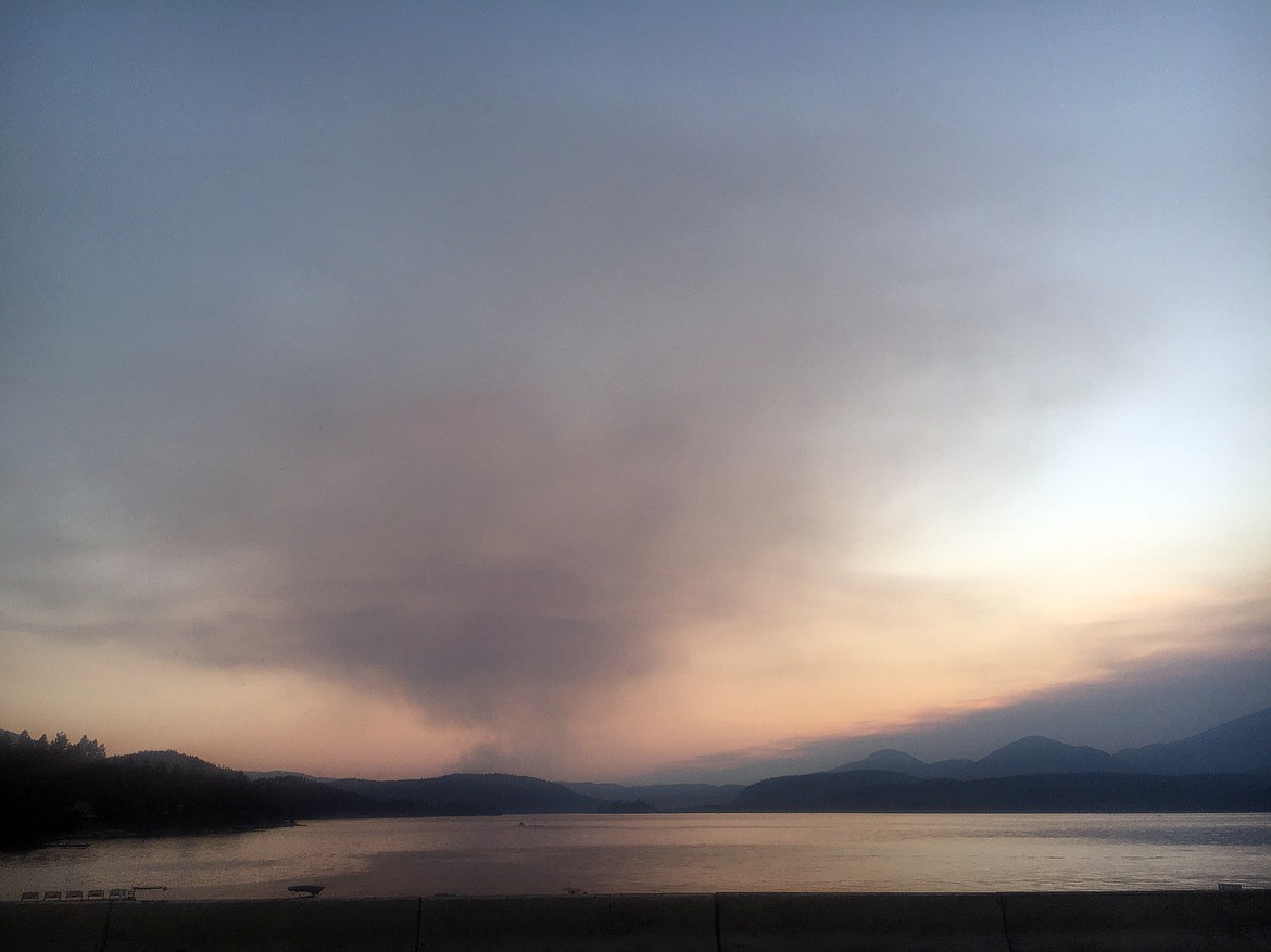
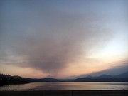
The plume of smoke from the Pioneer Fire, located 3 miles northwest of Priest River, as seen from the Long Bridge in Sandpoint.

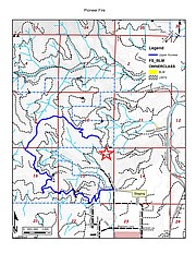
A map of the area near the Pioneer Fire. The fire is located to the north and northwest of the star on the map in sections 10 and 11.
▶️ Listen to this article now.
PRIEST RIVER — A fast-moving wildfire near Priest River prompted the evacuation of nearby residents Thursday evening.
The fire, reported about 1:30 p.m., had burned about 30 acres by 3 p.m. but despite an initial attack which included air support, the fire quickly grew to about 200 acres by early evening, according to Idaho Department of Lands officials.
The fire's proximity to Priest River — and residents in the area — prompted Bonner County Sheriff's Office to issue an evacuation order shortly before 7:30 p.m. Among those ordered to evacuation were residents in the Saddler Creek, Skunk Cabbage, Mundy and portions of Bodie Canyon Road and Slippery Slope areas due to the fire's proximity. About 8 p.m., the evacuation order was extended to residents along Highway 57, south of Bear Paw Road. Nixle alerts were issued to warn residents and BCSO personnel were going to door to door to alert residents.
Residents were directed to Priest River Community Church and those with large animals were directed to take them to the Newport Rodeo Grounds just across the border in Washington state.
Scott Phillips, policy and communications chief for the Idaho Department of Lands, said an initial aggressive attack was made on the fire and included more than 50 firefighters who are being supported from the air by three Fire Boss air tankers and a heavy-lift helicopter. Ground support includes 10 engines, 4 dozers, water tenders and an excavator.
Tom Fleer, IDL’s Pend Oreille Lake Supervisory Area manager reported a Type 3 incident management team, will arrive to take over management of the fire at 8 a.m. tomorrow. Type 3 teams typically provide extended initial attack on wildfires using resources from several organizations and are organized with a flexible, expandable command structure that can accommodate changing fire conditions.
Phillips said the cause of the fire is under investigation.
While Highway 57 out of Priest River, near the Pioneer Fire, is currently open, BCSO is asking residents to approach the area with caution and to not stop to take photos or for anything else because of the traffic congestion it causes.
Elsewhere in the region, firefighters from multiple cooperating agencies continue to battle large wildfires ignited by lightning storms that passed over the Idaho Panhandle National Forests in early July, IPNF public information officer Kary Maddox said in a press release.
Hot, dry and breezy conditions have contributed to increased fire activity. In addition, local fire resources have been further challenged by steep and rugged terrain, with additional new fire starts nearly every day, several of which appear to have been human caused, she said.
Currently, the largest fires on the IPNF are the:
• Trestle Creek Complex, close to 500 acres in five fires (8 miles northeast of Hope, Idaho)
• Character Complex, burning nearly 5,800 acres in two fires: the Deceitful Fire (about 3 miles north of Kellogg, Idaho and one mile south of the North Fork Coeur d’Alene River) and the Prichard Fire (about one mile from Eagle, Idaho)
• Stateline Complex, burning over 4,200 acres in 12 fires (about 6 miles southwest of St. Regis, Montana)
• Larkins Complex, burning about 2,500 acres in 12 fires (20 miles southeast of Avery, Idaho)
In addition, several large fires are burning on lands adjacent to the IPNF in Idaho and Montana.
“This level of fire activity is not normally seen in our area until August,” said Forest Supervisor Carl Petrick. “Recent record-breaking temperatures and an exceptionally dry winter and spring are causing extreme fire conditions.”
Fire officials plan their fire suppression strategies based on fire behavior, weather conditions, and availability of fire suppression resources. They are prepared with a contingency plan and ready to make adjustments if there are sudden changes in the status of any of these considerations.
Petrick is urging anyone who might be planning a visit to the IPNF in the coming months to give serious consideration to their plans, and make sure they have a backup plan as well.
“We normally welcome visitors to enjoy the many opportunities for camping, hiking, hunting, fishing and other activities offered in the beautiful mountains and rivers of the IPNF. Unfortunately, this year the accommodations might not be as comfortable or as safe as we would like,” said Petrick. “Dry conditions have resulted in lower than usual water levels in rivers and streams, the air is smoky from active fires, and there is an increased likelihood of meeting large fire equipment on forest roads. In the mountains, cell service is not always available, which can be critically important in an emergency.”
Fire burning on cliffs and steep slopes disturbs soil and vegetation, causing rockslides and burning debris to impact adjacent roads without warning. In situations such as this, the Forest Supervisor may choose to close an area, road or trail to entry or restrict specific activities in an area where that entry or activity might endanger public health or safety, hamper firefighters’ efforts to suppress an ongoing fire, or result in additional fires. Stage II Fire Restrictions went into effect in northern Idaho on July 12, prohibiting fires, confining smoking to vehicles, buildings, or designated areas, and restricting use of chainsaws, blasting, welding, and explosives during certain hours (go to www.idahofireinfo.com for more information). Additional closure orders restricting travel on specific roads and trails in the Idaho Panhandle National Forest have also been issued.
Petrick predicts a lengthy fire season.
“We’re facing a fire season that has the potential to last until November, stretching fire resources and personnel to the limit, and there is no end in sight to the hot temperatures and increasingly dry conditions. We need the public’s help to avoid human-caused fires and to help our crews fighting these large fires by considering a visit to an area that isn’t as heavily impacted by fires as the IPNF. Hopefully we can welcome our visitors back next summer, when they can once again enjoy clear skies, cool water, and safer roads and trails.”
Local area dispatch encourages Bonner County residents to sign up for Nixle alerts online or by texting their ZIP code to 888777.
For information on the Pioneer Fire go online to idl.idaho.gov/fire. For information on the other fires, go online to inciweb.nwcg.gov/
Video
Pioneer Fire